8 Biggest Countries In Africa

BSC Insights Admin
September 30, 2026
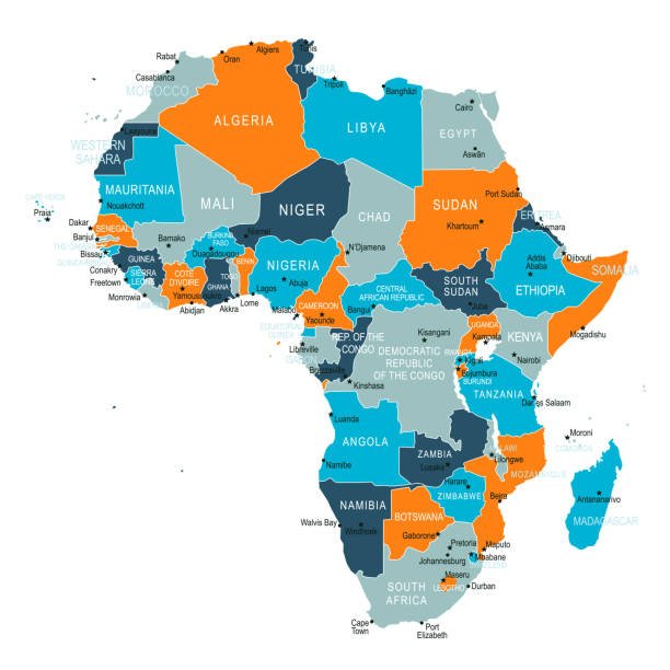
Identifying the 8 Biggest Countries In Africa is essential for understanding the sheer scale and geographic diversity of the worlds second largest continent. These nations span millions of square kilometers, covering everything from the vast Sahara Desert to the lush tropical rainforests of the central basin. Each of these large landmasses plays a pivotal role in the geopolitical and economic landscape of the region.
Mapping the land area of these states helps highlight the immense challenges and opportunities involved in managing such expansive territories. The distribution of these massive nations reveals the complex geological and historical processes that shaped the modern borders of the continent.
These are the 8 Biggest Countries In Africa
The African continent is home to fifty-four sovereign nations, but a small group of them occupies a disproportionately large percentage of its total landmass. When we look at the African countries that are the 8 Biggest Countries In Africa, we see a diverse list of states that range from the Mediterranean shores in the north to the Atlantic and Indian Ocean coasts in the south. These nations are not just large in terms of physical space but also in terms of their natural resources, biodiversity, and strategic importance to the global economy. Managing such vast areas requires significant infrastructure and administrative effort, which often dictates the developmental path of the country in Africa 8 Biggest Countries In Africa includes. The following list ranks these nations by their total land area, providing insight into their geography and the unique features that define their borders.
1. Algeria
Algeria is the largest nation on the continent, covering an expansive area of approximately 2,381,741 square kilometers. Located in North Africa, a vast majority of its territory is dominated by the Sahara Desert, which creates a unique set of challenges and opportunities for the government. Despite the arid nature of the interior, Algeria is incredibly rich in hydrocarbons, with massive reserves of natural gas and oil that form the backbone of its economy. Most of the population is concentrated in the northern regions along the Mediterranean coast, where the climate is more temperate and suitable for agriculture. The history of the nation is deeply tied to its geography, as the rugged Atlas Mountains have served as both a barrier and a stronghold for various civilizations over thousands of years. As an African country which is the largest by land area, Algeria maintains a significant influence over regional security and energy markets in both Africa and Europe. The government continues to invest in desert development projects to better utilize the immense space within its southern borders.
2. Democratic Republic of the Congo
The Democratic Republic of the Congo, often abbreviated as the DRC, follows closely as the second largest nation with an area of about 2,344,858 square kilometers. This central African giant is home to the worlds second largest tropical rainforest, which serves as a critical carbon sink for the entire planet. The geography of the DRC is dominated by the Congo River basin, a massive network of waterways that provides the primary mode of transport for many remote communities. The country is famous for its incredible mineral wealth, including significant deposits of cobalt, copper, and diamonds, which are essential for modern global technology. Because of its size and the density of its forests, infrastructure development remains a major hurdle, with many parts of the country still difficult to reach by road. As a primary country in Africa that is among the 8 Biggest Countries In Africa, the DRC shares borders with nine other nations, making it a central figure in continental diplomacy and trade. The sheer scale of its wilderness areas also makes it one of the most important zones for biodiversity conservation globally.
3. Sudan
Sudan is the third largest country on the continent, occupying roughly 1,861,484 square kilometers in the northeast. Before the secession of South Sudan in 2011, it was the largest nation in Africa, but even after the split, it remains a massive territory with a diverse landscape. The country is defined by the Nile River, which flows through its center and provides the lifeblood for its agricultural sector and growing urban centers. Sudan geography transitions from the arid deserts of the north to the more fertile savannahs and swamps in the south and west. The Red Sea coastline offers strategic maritime access, connecting the nation to global trade routes via the Suez Canal. As an African country which is one of the 8 Biggest Countries In Africa, Sudan has historically been a bridge between the Arab world and Sub-Saharan Africa. The government is currently navigating complex political transitions while attempting to manage the vast resources found within its diverse regions, including oil and gold.
4. Libya
Libya ranks as the fourth largest nation in Africa, covering approximately 1,759,540 square kilometers of mostly desert terrain in the north. Like its neighbor Algeria, Libya is dominated by the Sahara, with over 90 percent of its land classified as arid or semi-arid. Despite this, the country possesses the largest proven oil reserves on the continent, which has historically made it one of the wealthiest African nations per capita. The majority of the population lives in the coastal cities of Tripoli and Benghazi, where the Mediterranean climate allows for more comfortable living conditions. Libya geography has played a major role in its history, serving as a crossroads for ancient Phoenician, Roman, and Ottoman influences. As a significant country in Africa 8 Biggest Countries In Africa encompasses, its strategic location on the Mediterranean makes it a key partner for European nations regarding energy and migration. The vastness of the southern desert remains largely uninhabited but contains hidden aquifers and mineral potential that could drive future development.
5. Chad
Chad is the fifth largest country on the continent, spanning about 1,284,000 square kilometers in a landlocked position in north-central Africa. It is often referred to as the dead heart of Africa because of its remote location and the fact that a large portion of its northern territory is part of the Sahara. The country features a dramatic range of landscapes, from the volcanic Tibesti Mountains in the north to the fertile plains surrounding Lake Chad in the south. Lake Chad was once one of the largest freshwater bodies in the world, though it has shrunk significantly over recent decades due to climate change and irrigation. The nations economy has traditionally been based on livestock and agriculture, but the discovery of oil in the early 2000s has shifted its industrial focus. As one of the countries in Africa that are the 8 Biggest Countries In Africa, Chad plays a vital role in regional security, particularly in the Sahel region. The vast distances between its southern capital, N'Djamena, and its northern borders present unique logistical challenges for governance and trade.
6. Niger
Niger is the sixth largest nation in Africa, with a land area of roughly 1,267,000 square kilometers, situated in the heart of the West African Sahel. Over 80 percent of its territory is covered by the Sahara Desert, making it one of the hottest and most arid nations on earth. The Niger River flows through the southwestern corner of the country, providing essential water for the capital, Niamey, and the majority of the nations agricultural production. Niger is a global leader in the production of uranium, which is its primary export and a major source of foreign revenue. The northern regions are home to the Air Mountains and the Tenere Desert, areas that are famous for their stark beauty and nomadic Tuareg culture. As a prominent African country which is one of the 8 Biggest Countries In Africa, Niger faces significant environmental challenges related to desertification and food security. However, its vast landmass also holds untapped potential for solar energy and other mineral resources that are increasingly in demand.
7. Angola
Angola occupies the seventh spot on the list, covering approximately 1,246,700 square kilometers along the southwestern coast of the continent. Unlike the desert-dominated nations of the north, Angola features a diverse mix of tropical rainforests, central plateaus, and coastal plains. The country is exceptionally rich in natural resources, being one of the top oil and diamond producers in Africa. Since the end of its civil war in 2002, Angola has seen rapid urban development, particularly in its capital city, Luanda, which has become a major financial hub. The Kwanza River and numerous other waterways provide the nation with significant hydroelectric potential and fertile land for farming. As an African country which is one of the 8 Biggest Countries In Africa, Angola is a leading member of the Southern African Development Community. The government is currently focused on diversifying the economy to reduce its dependence on petroleum and better utilize its vast agricultural and tourism potential.
8. Mali
Mali is the eighth largest country in Africa, with a total land area of about 1,240,192 square kilometers located in the interior of West Africa. Like many other nations on this list, its northern half extends deep into the Sahara Desert, while the south is part of the more fertile Sudanian savannah. The Niger River acts as a vital artery for the nation, flowing in a great arc through its territory and supporting the historic cities of Timbuktu and Segou. Mali has a legendary history as the center of wealthy empires that controlled the trans-Saharan gold and salt trades for centuries. Today, gold mining remains the most important sector of the economy, making Mali one of the top producers of the precious metal on the continent. As a key member of the African countries that are the 8 Biggest Countries In Africa, Mali faces challenges related to its landlocked status and regional instability in its northern territories. Despite these hurdles, the country possesses a rich cultural heritage and vast areas of arable land that offer significant opportunities for future growth.
| Rank | Country Name | Total Land Area (sq km) | Primary Region |
|---|---|---|---|
| 1 | Algeria | 2,381,741 | North Africa |
| 2 | DR Congo | 2,344,858 | Central Africa |
| 3 | Sudan | 1,861,484 | Northeast Africa |
| 4 | Libya | 1,759,540 | North Africa |
| 5 | Chad | 1,284,000 | Central Africa |
| 6 | Niger | 1,267,000 | West Africa |
| 7 | Angola | 1,246,700 | Southern Africa |
| 8 | Mali | 1,240,192 | West Africa |
Reasons Why These Countries Are Among the Largest Nations in Africa
1. Geological Stability of the African Plate: The sheer size of these nations is partly due to the ancient and stable nature of the African tectonic plate, which has allowed for the formation of massive, continuous landmasses. Unlike other continents that are more fragmented by tectonic boundaries, much of Africa consists of large cratons that have remained intact for billions of years. This geological consistency has allowed for the creation of expansive desert plains and river basins that span thousands of kilometers without interruption. These vast physical foundations provided the canvas upon which modern national borders were eventually drawn.
2. Colonial Border Demarcation: Most of the borders for the 8 Biggest Countries In Africa were established during the late 19th century by European powers during the Scramble for Africa. These administrative lines were often drawn over large, sparsely populated areas like the Sahara or the Congo Basin to simplify colonial governance. Because these regions were difficult to navigate and map precisely, colonial authorities created massive territories rather than smaller, ethnically-aligned states. This historical process resulted in the creation of giant nations that consolidated many different traditional kingdoms into single administrative units.
3. Concentration of Major River Basins: Many of the largest countries in Africa are centered around the continents most significant river systems, such as the Nile, the Congo, and the Niger. These rivers served as the primary routes for exploration and trade, leading colonial and post-colonial governments to claim all the land surrounding these vital waterways. The Democratic Republic of the Congo, for example, is almost entirely defined by the drainage basin of the Congo River. Controlling an entire river system naturally leads to the formation of a large national territory due to the interconnected nature of the surrounding valleys and tributaries.
4. Expansion Across the Sahara Desert: Several of the nations on this list, including Algeria, Libya, Mali, and Niger, owe their massive size to the fact that they encompass huge portions of the Sahara Desert. In pre-modern and colonial times, these vast arid regions were often treated as single blocks of territory because they were difficult to settle or divide effectively. As modern states were formed, these desert expanses were incorporated into the national borders of the neighboring fertile regions. Consequently, which country that is among the 8 Biggest Countries In Africa often depends on how much of the Saharan interior it managed to claim during the era of border formalization.
5. Strategic Mergers and Historical Empires: Some large nations are the result of mergers between different colonial territories or the remnants of expansive historical empires. Sudan, for instance, was administered as a single unit by the British and Egyptians for decades, consolidating a vast area of the Nile valley into one state. Similarly, the borders of nations like Mali and Chad were influenced by the reach of ancient trade empires that once controlled large swathes of the Sahel. These historical precedents created a framework for large-scale governance that persisted into the era of modern independence.
6. Topographical Barriers and Natural Boundaries: The presence of massive natural barriers like mountain ranges or expansive coastlines helped define the outer limits of these giant nations. In countries like Angola and Algeria, the coastline provided a clear starting point for territorial expansion into the interior. These nations continued to expand until they met significant geographical obstacles or reached the limits of their administrative capacity. The resulting territories are often defined by these natural perimeters, creating the massive sovereign states we recognize today as the 8 Biggest Countries In Africa on the world map.
Conclusion
In summary, the 8 Biggest Countries In Africa represent a diverse group of nations that define the geographic and economic heart of the continent. From the Saharan reaches of Algeria and Libya to the tropical heart of the Democratic Republic of the Congo, these states manage some of the worlds most significant natural resources. The historical and geological factors that led to the creation of these massive territories continue to shape their developmental challenges and regional influence. As these nations grow and modernize, their ability to effectively govern such expansive landmasses will be critical for the future of the entire continent. Understanding which country that ranks among the 8 Biggest Countries In Africa provides essential context for anyone interested in the future of the global south.
Enjoyed this read?
Share it with your friends and colleagues.