Is Africa Bigger Than Greenland

BSC Insights Admin
September 30, 2026
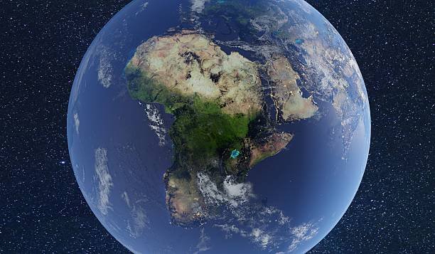
When examining a typical world map, particularly those based on the widely used Mercator projection, it's easy to fall prey to a common geographical illusion: that Greenland appears comparable in size, or even larger, than the entire continent of Africa. However, to answer the question, is Africa bigger than Greenland, the unequivocal truth is a resounding yes, Africa is dramatically larger than Greenland. This article will delve into the true landmasses of both geographical entities, explain why this widespread misconception exists, and highlight the immense scale and significance of the African continent.
The Astonishing Scale: Africa's True Gigantic Size
Africa is the world's second-largest continent, a vast landmass that spans an incredible area. Its sheer scale often goes unappreciated due to the distortions inherent in many global maps.
Africa's Actual Landmass
The continent of Africa covers approximately 30.37 million square kilometers (11.73 million square miles). To put this into perspective, Africa is so large that it could comfortably contain China, India, the United States, and most of Europe within its borders. It boasts a staggering 54 recognized countries, each with its unique culture, history, and geography. From the Sahara Desert in the north to the rainforests of the Congo Basin, and the savannas of East Africa to the diverse landscapes of the south, the continent's environmental and cultural diversity is unparalleled. This vastness contributes to its significant role in global climate, biodiversity, and human history. Understanding the true size of Africa is crucial for appreciating its global importance.
Greenland's Reality: The World's Largest Island
While often depicted as massive on certain maps, Greenland, an autonomous territory of the Kingdom of Denmark, is in reality far smaller than Africa. Greenland measures approximately 2.166 million square kilometers (836,330 square miles). Although it holds the title of the world's largest island, its land area is a mere fraction of Africa's. To compare directly, Africa is nearly 14 times larger than Greenland. To give another perspective, Greenland is smaller than Algeria, the largest country in Africa, and significantly smaller than the Democratic Republic of Congo or Sudan. Its immense ice sheet covers about 80% of its surface, making much of its land uninhabitable and distinguishing it dramatically from the diverse and densely populated continent of Africa.
Here's a quick comparison:
- Africa's Area: ~30.37 million sq km (~11.73 million sq mi)
- Greenland's Area: ~2.166 million sq km (~0.836 million sq mi)
- Ratio: Africa is roughly 14 times larger than Greenland.
Understanding Map Projections and Distortions
The primary reason for the common misperception regarding the comparative sizes of Africa and Greenland lies in the way our world is typically represented on flat maps. The Earth is a sphere (or more accurately, an oblate spheroid), and accurately translating a three-dimensional surface onto a two-dimensional plane inevitably leads to distortions.
The Mercator Projection: A Necessary Evil?
The most famous and widely used map projection is the Mercator projection, created by Gerardus Mercator in 1569. This projection was revolutionary for nautical navigation because it preserved the true shapes of landmasses and angles, meaning that a straight line on the map represented a constant compass bearing. This was incredibly useful for sailors but came at a significant cost: distortion of area, particularly at higher latitudes. On a Mercator map:
- Areas closer to the poles appear significantly larger than they are in reality.
- Areas near the equator retain a more accurate representation of their true size.
This is why Greenland, located far north, appears massively inflated, while Africa, straddling the equator, is depicted much closer to its actual proportions relative to itself, but looks smaller in comparison to the distorted high-latitude landmasses. The Mercator projection stretches the landmasses vertically and horizontally as one moves away from the equator, making places like Greenland, Canada, and Russia seem much larger than their actual land area.
Alternative Projections for True Area
While the Mercator projection is excellent for navigation, it is highly misleading for understanding the relative sizes of continents and countries. Geographers and cartographers have developed other projections that prioritize area accuracy over shape or direction. Some notable examples include:
- Gall-Peters Projection: This projection attempts to represent the relative sizes of landmasses accurately, though it distorts their shapes, making some appear elongated. It has gained popularity for its focus on true area.
- Eckert IV Projection: This is a pseudocylindrical projection designed to show world area with minimal distortion, particularly for the central latitudes.
- Robinson Projection: A compromise projection that aims for a good overall balance of size, shape, and distance distortion. While not perfectly accurate in area, it is less distorting than Mercator.
These alternative maps provide a much more accurate visual understanding of the actual sizes of continents and countries, clearly illustrating that Africa dwarfs Greenland and many other landmasses often perceived as larger.
Why the Misconception Persists
The enduring belief that Greenland is comparable to Africa in size isn't just a simple oversight; it's a deeply ingrained geographical misconception propagated by decades, if not centuries, of visual bias.
Visual Bias from Childhood Maps
Most people, from elementary school classrooms to news reports, have primarily encountered world maps based on the Mercator projection. This constant exposure to distorted representations has hardwired an inaccurate mental image of the world's landmasses. Children grow up seeing Greenland as a giant icy land and Africa as a relatively smaller, centrally located continent, leading to a skewed perception that is difficult to correct later in life. This map bias is a powerful factor in perpetuating the myth.
Lack of Geographical Education
Another contributing factor is the limited education on cartography and map projections. Many educational curricula do not sufficiently explain how maps are created, their inherent limitations, and the specific distortions of different projections. Without this fundamental understanding, people naturally assume that the maps they see accurately depict reality in all aspects, including size. This lack of critical geographical literacy allows the Mercator projection distortion to continue influencing public perception.
The Significance of Africa's Scale
Recognizing the true scale of Africa goes beyond mere geographical accuracy; it's crucial for understanding the continent's immense global importance in various domains.
Demographic and Cultural Richness
Africa is the second most populous continent, home to over 1.4 billion people, representing a vast demographic force. This immense population is characterized by incredible diversity, with thousands of distinct ethnic groups, languages, and cultures. The continent is a cradle of humanity, with a rich history that has shaped global civilization. Its demographic growth and youthful population are significant factors in global economics and development.
Economic Potential and Natural Resources
Beneath Africa's vast surface lies an abundance of natural resources. The continent is rich in minerals such as gold, diamonds, platinum, cobalt, and uranium, as well as significant oil and natural gas reserves. Its expansive land provides vast agricultural potential, with diverse climates supporting a wide range of crops. The growing economies across Africa, coupled with its natural wealth, position it as a continent with enormous untapped economic potential and a crucial player in global supply chains. Understanding Africa's size helps to grasp the sheer scale of these resources.
Geopolitical Importance
Africa's strategic location, bridging the Atlantic and Indian Oceans and bordering the Mediterranean and Red Seas, gives it considerable geopolitical importance. Its growing population, increasing economic integration, and expanding influence in international bodies mean that Africa is an increasingly vital voice on the global stage. Major global powers are keenly aware of the continent's strategic value, leading to increased engagement in trade, diplomacy, and development initiatives.
Environmental Diversity
From the arid Sahara Desert, the largest hot desert in the world, to the lush Congo Rainforest, the second-largest rainforest globally, and the iconic savannas teeming with wildlife, Africa boasts an extraordinary range of ecosystems. This environmental diversity is critical for global biodiversity, harboring a vast number of plant and animal species, many of which are endemic to the continent. The conservation of these unique environments is a global challenge and responsibility, underscoring the continent's ecological significance.
Debunking Other Common Map Misconceptions
The Africa-Greenland comparison is just one of many geographical illusions perpetuated by the Mercator projection. Other common distortions include:
- Canada and Russia: Both countries appear much larger than their actual size due to their high northern latitudes. In reality, Africa is larger than Russia and significantly larger than Canada.
- Scandinavia: The Nordic countries look disproportionately large. Sweden alone appears to be a major landmass, while in reality, it is much smaller compared to African nations.
- South America: Often perceived as smaller than North America, South America is actually comparable in land area, and even slightly larger than North America if Greenland is excluded.
These world map inaccuracies explained reveal how deeply our perception of global geography can be shaped by the cartographic choices made centuries ago.
Conclusion
In conclusion, the answer to the question, is Africa bigger than Greenland, is an unequivocal and emphatic yes. Africa is roughly 14 times larger than Greenland, a fact often obscured by the prevalent Mercator projection distortion on many world maps. By understanding the science behind map projections and actively seeking out more accurate representations of our planet, we can overcome these common geographical misconceptions. Recognizing the true size of Africa is not just about correcting a fact; it's about appreciating the immense diversity, potential, and global significance of a continent that has too often been visually and conceptually diminished. A more accurate understanding of global geography enriches our perception of the world and the interconnectedness of its diverse regions.
Enjoyed this read?
Share it with your friends and colleagues.