Which Country In Africa Is Farthest South

BSC Insights Admin
October 01, 2026
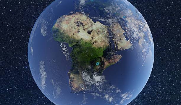
South Africa is the **African country which is farthest south**, reaching a geographical extremity at Cape Agulhas where the Atlantic and Indian Oceans officially meet. This nation occupies the southernmost tip of the continent, with its territory extending far into the southern temperate zone and even including sub-antarctic islands located much deeper in the Southern Ocean. Understanding the geography of this region is essential for comprehending global maritime routes and the unique biodiversity found at the end of the African landmass.
The positioning of the southern cluster of nations defines the climatic and economic landscape of the entire Sub-Saharan region. This article provides an extensive look at the nations that occupy the lower reaches of the continent and explains the significance of their proximity to the southern pole.
These are the Countries and the African Country Which Is Farthest South
When looking at a map of the world, the southern tip of the African continent appears as a sharp point reaching toward the Antarctic circle. The African country which is farthest south is South Africa, but it is surrounded by a group of nations that together form the Southern Africa region, each contributing to the unique geography of the area. While some are landlocked and others are island nations, their latitudinal positions make them the southern guardians of the continent. Below is an in-depth analysis of these nations and the specific geographic markers that define their southern reach.
1. South Africa
South Africa is the definitive answer when identifying which nation lies at the absolute bottom of the continent. The country's southernmost point is Cape Agulhas, located at a latitude of approximately 34 degrees south, which is the actual dividing line between the Atlantic and Indian Oceans. Many people mistakenly believe the Cape of Good Hope is the farthest south, but Agulhas sits about 150 kilometers to the southeast and reaches slightly further into the sea. Beyond the mainland, South Africa also exercises sovereignty over the Prince Edward Islands, which are located nearly 2,000 kilometers south of Cape Town in the sub-antarctic region. This makes the country's actual reach extend much further south than any other sovereign state on the continent. The climate here is Mediterranean in the southwest, allowing for a world-renowned wine industry that benefits from the cool breezes of the Southern Ocean. South Africa’s position has made it a historical hub for maritime explorers and a modern center for international trade.
2. Lesotho
Lesotho is a unique geographic entity because it is a high-altitude kingdom entirely surrounded by South Africa, the **country in Africa farthest south**. Because it is an enclave, its southern border is also one of the southernmost boundaries on the continent, even though it does not have a coastline. Known as the "Kingdom in the Sky," Lesotho has the highest low point of any country in the world, with its entire territory sitting above 1,400 meters. Its southern districts, such as Quthing and Qacha's Nek, experience cold winters with frequent snowfall due to their latitudinal and altitudinal positions. Lesotho serves as a vital water tower for the region, with the Orange River beginning its journey in the Lesotho highlands before flowing south and west. The country’s existence is deeply tied to the southern geography of the continent, as its mountains form part of the Great Escarpment that defines the interior plateau of Southern Africa. Its proximity to the southern tip ensures that it remains one of the coldest and most rugged nations in the region.
3. Namibia
Namibia is located on the southwestern coast of Africa and shares a long southern border with South Africa along the Orange River. While it does not reach as far south as Cape Agulhas, its southern regions like the Karas Region are significantly closer to the pole than most other African territories. The southern Namib Desert meets the Atlantic Ocean in a spectacular display of dunes and cold water currents known as the Benguela Current. This current brings nutrient-rich, icy water from the south, which supports massive seal colonies and a thriving fishing industry. The town of Lüderitz and the surrounding diamond areas represent some of the most southern urban settlements on the Atlantic side of the continent. Namibia's geography is defined by its arid southern landscape, where the Fish River Canyon, one of the largest in the world, carves through the southern plateau. Its southern boundary is a critical ecological transition zone between the desert and the more temperate southern Cape region.
4. Eswatini
Eswatini, formerly known as Swaziland, is one of the smallest nations in the region and is situated between South Africa and Mozambique. Its southern border sits at a latitude that places it firmly within the southern cluster of nations, sharing much of the same climate and ecology as the neighboring South African provinces. The southern part of the country is dominated by the Lowveld, a region of rolling hills and savannah that is home to several important wildlife reserves. Eswatini maintains close economic and cultural ties with the African country which is farthest south, as it is nearly surrounded by South African territory on three sides. The Great Usutu River flows through the southern regions, providing water for the sugar plantations that drive the national economy. Despite its small size, its position in the southern latitudes ensures that it experiences the seasonal shifts characteristic of the Southern Hemisphere. It serves as a cultural bridge in the south, preserving ancient traditions within a modernizing regional economy.
5. Botswana
Botswana is a landlocked nation located directly to the north of South Africa, placing it in the heart of the southern African plateau. The Tropic of Capricorn passes through the middle of the country, meaning the southern half of Botswana is technically outside the tropics and within the southern temperate zone. The southern districts, including the capital city Gaborone, are located just a short distance from the South African border, making them quite far south in the continental context. The Kalahari Desert covers much of the southern and western parts of the country, creating a vast, arid wilderness that is home to unique desert-adapted wildlife. Botswana's southern geography is characterized by flat plains and ancient riverbeds that only flow during exceptional rainy seasons. Because it shares such a large border with the **African country which is farthest south**, Botswana is a key player in the southern regional trade blocks. Its southern location contributes to its relatively stable climate, though it can experience extreme temperature fluctuations between day and night.
6. Zimbabwe
Zimbabwe is situated in the southern interior of the continent, bordered by the Limpopo River to the south, which separates it from South Africa. While it is further north than the nations previously mentioned, it is still considered a core part of the Southern Africa region. The southern provinces of Matabeleland South and Masvingo are semi-arid regions that reflect the transition from the lush interior to the drier southern plains. Zimbabwe’s southern border is a major transit point for goods moving between the country in Africa farthest south and the rest of the central continent. The Great Zimbabwe ruins, located in the southern part of the country, stand as a testament to the ancient civilizations that thrived in this southern highland region. The climate in the south is generally warmer than in the eastern highlands, but it still feels the influence of the cold fronts that move up from the Southern Ocean. Its position makes it a critical geopolitical link between the absolute south and the tropical center of Africa.
7. Mozambique
Mozambique has a coastline that stretches over 2,400 kilometers, with its southern tip reaching down to the border of South Africa’s KwaZulu-Natal province. The southern part of Mozambique, including the capital Maputo, is located at a latitude that makes it one of the southernmost coastal regions on the Indian Ocean side of Africa. This area is characterized by beautiful beaches, coral reefs, and a subtropical climate that is heavily influenced by the warm Agulhas Current flowing from the north. The Maputo Elephant Reserve in the south is a critical conservation area that links the southern ecosystems of Mozambique and South Africa. Mozambique’s southern ports are vital for the landlocked nations of the interior, providing a gateway to the sea for Zimbabwe, Eswatini, and parts of South Africa. The southern region is the most developed part of the country, benefiting from its proximity to the economic powerhouses of the far south. Its geography is a blend of coastal lowlands and fertile river valleys that support a large portion of the national population.
8. Madagascar
Madagascar is a massive island nation located in the Indian Ocean, and its southern tip, Cap Sainte Marie, is one of the southernmost points of African sovereign territory. This southern extremity reaches a latitude of about 25 degrees south, placing it well within the southern temperate zone. The southern part of Madagascar is drastically different from the lush northern rainforests, featuring a unique "Spiny Forest" ecosystem that is home to endemic species found nowhere else on earth. The climate in the south is semi-arid and prone to droughts, reflecting its distance from the equatorial rain belts. Madagascar’s southern location means it is often the first to feel the effects of powerful cyclones that form in the Indian Ocean and move toward the continent. The culture in the south is distinct, with pastoralist groups like the Antandroy and Mahafaly maintaining ancient traditions centered around cattle. Its position in the southern Indian Ocean makes it a biological treasure trove and a key geographic marker for the southeastern reaches of Africa.
9. Mauritius
Mauritius is an island nation located far to the east of Madagascar, but its latitudinal position at 20 degrees south makes it a significant part of the southern African island group. While it is not the **African country which is farthest south** in terms of mainland geography, its territory includes islands like Rodrigues that sit firmly in the southern waters. Mauritius was formed by volcanic activity and is surrounded by protective coral reefs, making its southern coastline rugged and dramatic. The southern part of the island, particularly around Le Morne Brabant, is known for its steep cliffs and powerful sea currents that move up from the Southern Ocean. The nation’s economy is one of the most developed in Africa, leveraging its strategic southern location to become a hub for international finance and luxury tourism. Mauritius experiences a tropical maritime climate, but its southern position means it has distinct seasons with cooler, drier winters. It serves as a vital maritime link between Africa, Asia, and Australia, occupying a strategic patch of the southern sea.
10. Reunion (Overseas Department of France)
While technically a department of France, Reunion is geographically part of the African island chain and sits slightly further south than Mauritius. Located at about 21 degrees south, it is a volcanic island featuring one of the most active volcanoes in the world, Piton de la Fournaise. The southern part of the island is often referred to as "le Sud Sauvage" (the Wild South) due to its untamed basaltic coastline and lush tropical vegetation. Reunion’s southern location makes it a critical site for atmospheric and oceanic research, as it sits in the path of the trade winds and southern currents. The island’s terrain is incredibly steep, with peaks reaching over 3,000 meters, which creates various microclimates ranging from tropical at the coast to alpine in the interior. Though it is politically part of Europe, its geographic reality is entirely southern African, contributing to the regional diversity of the southwest Indian Ocean. Its proximity to the southern pole allows for unique astronomical observations, making it a key location for science in the Southern Hemisphere.
Reasons Why These Countries are Farthest South in Africa
1. Latitudinal Positioning on the Globe: The most obvious reason for which country that is farthest south in Africa is its specific coordinate on the Earth's grid. South Africa reaches down to 34.8 degrees south, which is the physical limit of the continental crust in the Southern Hemisphere. This **maritime trade routes** gateway exists because the African plate tapers off into a point rather than extending into a broad landmass like Antarctica or South America. This tapering allows the oceans to circulate around the tip, creating the unique meeting point of the Atlantic and Indian waters. The latitude alone determines the amount of solar radiation and the seasonal cycles these nations experience, separating them from the tropical center.
2. The Influence of the Agulhas and Benguela Currents: The southern reach of the continent is defined by the massive oceanic currents that hug its coastlines. The warm Agulhas current flows down the east coast, while the cold Benguela current moves up the west, meeting at the southern tip of the African country which is farthest south. These currents dictate the climate, marine life, and even the fog patterns of the southern nations, making the geography of the south inseparable from the physics of the ocean. This meeting of currents is one of the most powerful hydrologic events on the planet, creating a rich environment for biodiversity. The thermal contrast between these two bodies of water is a major driver of the regional weather systems.
3. Tectonic Plate Structure: The shape of the African continent is a result of the breakup of the supercontinent Gondwana millions of years ago. As South America, Antarctica, and Australia drifted away, the southern part of Africa was left as a stable, ancient craton that ends abruptly at the Agulhas Bank. The **African countries that are farthest south** sit on this stable geological foundation, which features the Great Escarpment—a massive mountain range that encircles the southern plateau. This geological "edge" is what gives the southern tip its dramatic mountains and cliffs. The continental shelf extends quite far south underwater, providing a shallow area that is one of the world's richest fishing grounds.
4. Southern Hemisphere Atmospheric Circulation: The southern nations are positioned in a way that they are directly influenced by the "Roaring Forties," the powerful westerly winds that circulate the globe in the southern latitudes. These winds bring cold fronts and rain to the southern Cape and influence the sailing routes that have been used for centuries. The **African country which is farthest south** acts as a windbreak for these atmospheric forces, protecting the interior of the continent from the full brunt of the Southern Ocean's storms. This positioning creates a unique climatic transition from the temperate south to the subtropical north. The seasonal shift in the pressure belts ensures that the south receives most of its rainfall during the winter months.
5. Geopolitical and Economic Grouping (SADC): Being farthest south has led to the creation of a distinct regional identity and economic block known as the Southern African Development Community. These countries in Africa that are farthest south share infrastructure, power grids, and trade agreements that are centered around the economic hub of South Africa. This southern alignment is a result of shared history, geography, and the need to manage transboundary resources like the Orange and Limpopo rivers. The regional connectivity is a direct response to their shared southern location, facilitating the movement of people and goods across the lower half of the continent. This cooperation is essential for the stability and development of the entire Sub-Saharan region.
6. Proximity to the Sub-Antarctic Zone: The southern cluster of nations, particularly South Africa and the various island states, serve as the closest inhabited landmasses to the Sub-Antarctic islands and the Antarctic continent itself. This geographic proximity makes the country in Africa farthest south a vital base for scientific research and polar expeditions. Cape Town is one of the primary "gateway cities" to Antarctica, providing logistics and support for missions heading to the frozen south. This relationship with the polar region defines the southern identity of these nations, as they are the first to encounter the cold air masses moving up from the ice. This proximity also means that the southern waters are frequented by whales and other migratory marine species that travel between the tropics and the poles.
Conclusion
In conclusion, South Africa is the African country which is farthest south, standing as the literal and symbolic end of the continent at Cape Agulhas. While it is the definitive geographic anchor, the surrounding nations of the Southern Africa region share in the unique environmental and economic characteristics that come with living in the southern latitudes. From the mountain peaks of Lesotho to the desert shores of Namibia, the geography of the farthest south is one of the most diverse and strategically important in the world. As global climate patterns shift and maritime trade evolves, the importance of this southern gateway will only continue to grow. Understanding the location and the reasons behind the southern extremity of Africa provides a deeper appreciation for the continent's vast scale and its connection to the global oceans. Ultimately, the southern tip of Africa remains one of the world's most iconic landmarks, marking the boundary where two great oceans and a magnificent continent meet.
Enjoyed this read?
Share it with your friends and colleagues.