Which Country In Africa Has No River

BSC Insights Admin
October 01, 2026
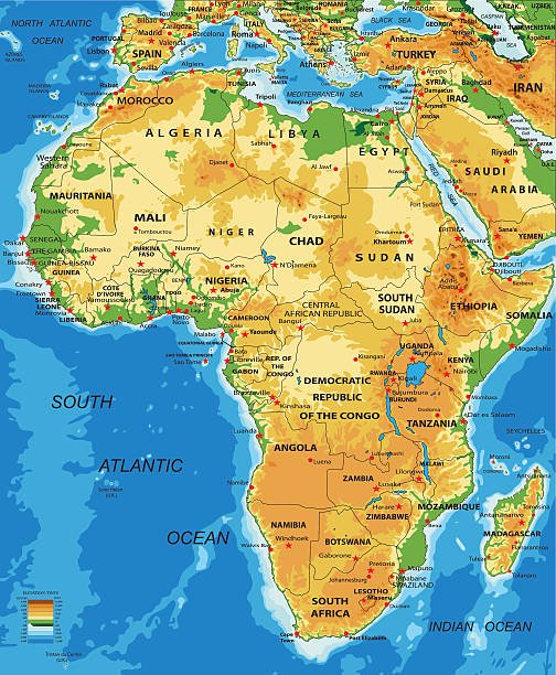
Determining which country that has no river in Africa is a journey into the most arid and geographically unique landscapes on the continent. Libya is the most prominent nation that lacks any permanent, year-round flowing rivers due to its position within the heart of the Sahara Desert. This absence of surface water has forced these territories to develop some of the most advanced underground water extraction systems in human history to support their populations and agricultural needs.
The lack of permanent waterways is a defining characteristic for several nations, particularly those situated in desert belts or on small volcanic islands. By exploring how these countries manage their water resources, we can understand the incredible resilience and engineering ingenuity required to thrive in environments where the sky and the sand dominate the horizon.
These are the Countries that have no river in Africa
While the African continent is home to massive river systems like the Nile, the Congo, and the Niger, several nations do not possess a single permanent river within their sovereign borders. These countries must rely on ephemeral streams, known as wadis, which only flow after rare rainfall events, or they must tap into ancient fossil aquifers buried deep beneath the earth. For island nations, the challenge is even more acute, as the limited land area and porous volcanic soil often prevent the formation of lasting river channels. This list examines the African countries that have no river and the unique hydrological conditions that define their survival and development in the modern era.
1. Libya
Libya is the largest African country which has no river that flows throughout the entire year, as nearly ninety percent of its territory is covered by the unforgiving Sahara Desert. The country relies heavily on "wadis," which are dry riverbeds that can transform into raging torrents for a few hours or days following a desert storm, but they quickly disappear into the thirsty sands. To solve this existential water crisis, Libya constructed the Great Man-Made River, a massive network of pipes that transports water from ancient fossil aquifers in the southern desert to the coastal cities. This project is often described as one of the greatest engineering feats of the twentieth century, providing the majority of the country's drinking and irrigation water. Without this artificial river system, major cities like Tripoli and Benghazi would struggle to sustain their large populations. The reliance on underground water highlights the extreme aridity of the Libyan landscape and the necessity of innovative technology in the absence of natural surface water. Examples of these underground sources include the Nubian Sandstone Aquifer System, which Libya shares with several of its neighbors.
2. Djibouti
Djibouti is another nation where the harsh, volcanic landscape has resulted in a complete lack of permanent rivers flowing within its borders. The territory is characterized by rocky plateaus, salt flats, and dormant volcanoes, creating an environment where rainfall is so scarce that water quickly evaporates or sinks into the porous earth. Djibouti’s most famous water body is Lake Assal, which is the saltiest lake in the world and the lowest point in Africa, but it does not provide fresh water for the citizens. To meet the demands of its urban centers, the country has traditionally relied on groundwater and, more recently, a massive cross border pipeline that brings fresh water from Ethiopia. The government has also invested in desalination plants to convert seawater into a drinkable resource, ensuring that the strategic port city can continue to function as a global logistics hub. The absence of rivers makes water one of the most precious commodities in Djibouti, influencing everything from national security to urban planning. This arid reality has turned Djibouti into a leader in geothermal and desalination research on the continent.
3. Cape Verde
Cape Verde is a volcanic archipelago located in the central Atlantic Ocean that suffers from a chronic lack of permanent rivers due to its rugged terrain and frequent droughts. The islands are composed of porous volcanic rock that allows what little rainwater falls to seep rapidly into the ground, preventing the formation of lasting surface streams. For centuries, the people of Cape Verde have struggled with water scarcity, which has historically led to periods of famine and significant migration to the diaspora. Today, the nation has become a global model for water management in island settings, utilizing advanced desalination technology to provide water for its tourism and residential sectors. In rural areas, "fog harvesting" and the construction of small dams help to capture seasonal moisture, but these do not constitute permanent rivers. The lack of flowing water has shaped the culture and history of the islands, making the "morna" music often reflect the longing for rain and the resilience of the islanders. Cape Verde’s success in maintaining a high standard of living without rivers is a testament to its efficient governance and technical adaptation.
4. Seychelles
Seychelles is a breathtaking island nation that, despite its lush tropical appearance, does not possess any major permanent rivers on most of its smaller islands. The granitic islands like Mahe do have small streamlets and mountain cascades that flow during the rainy season, but they are not large enough to be classified as permanent rivers by international standards. These islands are essentially the peaks of a submerged mountain range, and the limited catchment areas mean that water moves quickly to the sea. During the drier months, many of these streams can dry up completely, forcing the government to rely on sophisticated reservoirs and desalination plants to maintain a steady supply for the tourism industry. The coral islands in the outer regions of the archipelago have no surface water at all, relying entirely on collected rainwater and small lenses of brackish groundwater. This geographic limitation has made water conservation a primary educational focus in Seychelles, where every drop is managed with care. The absence of large rivers is a key reason why the nation has such pristine coastal waters, as there is little sediment runoff to cloud the coral reefs.
5. Comoros
Comoros is a volcanic archipelago in the Mozambique Channel where the geology of the islands prevents the existence of permanent flowing rivers. The islands, particularly Grande Comore, are made of relatively young volcanic rock that is highly porous, meaning that even heavy tropical rains disappear almost instantly into the subterranean layers. Because the water does not stay on the surface long enough to form riverbeds, the local population has historically relied on "impluviums" to collect and store rainwater from roofs and paved surfaces. In some coastal areas, people use wells to tap into freshwater lenses that sit above the seawater, but these are often at risk of contamination. The lack of rivers has limited the development of large scale agriculture, leading the country to focus on high value niche crops like vanilla and ylang ylang that are less water intensive. The government is working with international partners to improve water security by drilling deeper wells and improving storage infrastructure. This lack of surface water is a defining feature of the Comorian landscape, making the seasonal rains the most important event of the year.
6. Eritrea
Eritrea is characterized by an extremely arid and semi arid climate where the few waterways that exist are almost entirely ephemeral. While the Setit River on the border with Ethiopia is a permanent stream, the vast majority of the internal Eritrean territory has no permanent rivers that flow year round. The most important inland streams, such as the Gash and the Barka, are seasonal and only flow during the brief summer monsoon before disappearing into the desert sands or the Red Sea. This seasonal nature of the water supply has led to the development of an extensive system of dams and terracing to capture and preserve every drop of moisture for the agricultural sector. The Eritrean highlands are subject to intense erosion, and without permanent rivers to provide a steady supply, the management of the soil and seasonal runoff is critical for food security. The people of Eritrea have a long tradition of "spate irrigation," where they divert floodwaters into their fields, showing a deep understanding of the local hydrological cycle. This African country which has no river interior has built its national identity around the themes of self reliance and the mastery of its harsh environment.
7. Mauritania
Mauritania is a vast Saharan nation where the only permanent river is the Senegal River, which forms its southern border with Senegal and Mali. Internally, the country is almost entirely devoid of permanent surface water, with the landscape dominated by shifting sand dunes and rocky plateaus. The northern and central regions of Mauritania are among the driest places on Earth, where wadis may stay dry for years at a time before a single rain event brings them to life. To support its population and its massive iron ore mining industry, the country relies on groundwater from deep aquifers and the pipeline from the Senegal River. In the capital of Nouakchott, water is a precious commodity that was historically trucked in before the completion of a major water project that brings water from hundreds of kilometers away. The lack of internal rivers has made the nomadic way of life a historical necessity for many Mauritanians, as they move between oases and seasonal pastures. This arid geography is a central part of the Mauritanian experience, influencing its traditional architecture and social structures.
8. Algeria (Southern Regions)
While northern Algeria has several permanent rivers like the Chelif, the vast majority of the country—the southern Sahara region—is a territory with no permanent rivers. This southern zone, which makes up over eighty percent of the national land area, is an African country which has no river in its desert heartland. The inhabitants of the Saharan oases have for centuries used "foggara" systems, which are underground channels designed to bring water from distant aquifers to the surface without evaporation. These ancient engineering marvels allowed for the creation of palm groves and gardens in places where surface water is non existent. Today, the Algerian government uses modern drilling technology to tap into the Albian Aquifer, one of the largest underground water reserves in the world, to support new agricultural projects in the desert. The lack of surface rivers in the south is balanced by this incredible wealth of subterranean water, which the nation is now beginning to utilize on an industrial scale. The contrast between the river rich north and the riverless south is a defining feature of Algeria’s national geography.
9. Tunisia (Southern Regions)
Tunisia is another North African nation where the southern provinces lack any permanent rivers and must rely on wadis and groundwater. As you move south toward the Sahara, the rivers of the north disappear and are replaced by "chotts," which are massive salt pans that occasionally fill with water but are mostly dry and barren. The most famous of these is the Chott el Djerid, which appears as a shimmering mirage of water but holds no flowing river. To support life in the south, Tunisia has invested heavily in water transfer projects and the utilization of deep aquifers that were once used by the Romans. The lack of rivers in the southern regions has forced the tourism and agricultural sectors to be extremely efficient with their water usage. Cities like Tozeur and Nefta have survived for millennia by carefully managing their oasis springs, showing that human civilization can flourish even in a country in Africa has no river in its southern reaches. This arid landscape was famously used as a filming location for movies like Star Wars, highlighting its otherworldly and waterless appearance.
10. Somalia (Northern Regions)
Northern Somalia, including the regions of Somaliland and Puntland, is an extremely arid area that possesses no permanent rivers, unlike the southern part of the country where the Juba and Shabelle rivers flow. This northern zone is characterized by rugged mountains and coastal plains where water is only found in seasonal streams that flow briefly after the monsoon rains. The local communities are primarily nomadic pastoralists who have developed a deep knowledge of where to find "balleys" or small reservoirs and "berkads" which are traditional water storage tanks. Because there are no permanent rivers, the competition for water can be intense, and the management of wells is a central part of the local social and legal systems. The lack of surface water has limited the development of large scale irrigation, but it has fostered a resilient livestock industry that is the backbone of the region's export economy. In recent years, international aid has focused on building more modern water infrastructure to help these communities survive the increasingly frequent and severe droughts. The absence of rivers in northern Somalia is a major geographic factor that distinguishes the north from the more agricultural south.
Reasons Why These Countries Have No River in Africa
1. Position within the Subtropical High-Pressure Belt: The primary reason why several countries in Africa that have no river exist is their location within the horse latitudes, specifically the Sahara and the Horn of Africa. These regions are dominated by descending dry air that prevents the formation of rain clouds for most of the year, leading to extremely low annual precipitation. When the amount of water leaving the ground through evaporation exceeds the amount coming down from the sky, permanent rivers simply cannot form. Instead, the water is held in the ground or lost to the atmosphere, leaving the landscape dry and scarred with empty riverbeds. This global atmospheric circulation is the fundamental architect of the riverless zones on the continent. These belts of high pressure create the "dead zones" of the hydrological cycle where flowing water is a rarity.
2. Porous and Volcanic Geological Structures: In island nations like Cape Verde, Seychelles, and Comoros, the rock beneath the surface is often too porous to hold water in a channel. Volcanic soil and granitic cracks allow rainwater to seep down into the earth's interior almost as soon as it touches the ground. Because the water cannot collect and flow across the surface, it never reaches the critical mass needed to carve out a permanent riverbed. This geological "sieve" means that even in areas with high tropical rainfall, the water remains hidden underground rather than flowing in visible rivers. This geological reality is why many of these beautiful islands must still rely on desalination despite being surrounded by water. The physical structure of the land itself is the primary barrier to river formation.
3. Extreme Rates of Evaporation in Desert Climates: In nations like Libya and Mauritania, the intense heat of the sun causes any standing or flowing water to evaporate at a staggering rate. Even if a river were to start flowing from a mountain range, it would likely disappear into the air long before it reached the sea or a major lake. This high "evaporative demand" means that only the largest and most powerful rivers, like the Nile, can survive a journey through the desert. Smaller streams are simply "eaten" by the dry air and the hot sand before they can become permanent features of the landscape. This thermal barrier is a constant challenge for water engineers who must use covered pipes and underground channels to prevent the sun from stealing the nation's water. The heat is a silent predator that eliminates surface water across millions of square kilometers.
4. Limited Land Area and Small Catchment Basins: Many of the nations without rivers are small islands where the distance from the highest point to the sea is only a few kilometers. For a permanent river to form, there must be a large enough area to collect rainfall and funnel it into a single path that flows year round. On small islands like the Seychelles or the smaller Comorian isles, there simply isn't enough land to create a "catchment" that can sustain a river through the dry season. The water reaches the ocean so quickly that it never has the chance to establish a lasting presence on the land. These nations are essentially "water sheds" rather than "water holders," as the geography favors rapid runoff over steady flow. Size is a limiting factor that dictates the hydrological possibilities of a sovereign territory.
5. Historical Depletion of Ancient Surface Water: Some regions that are now without rivers were once much wetter thousands of years ago during the "African Humid Period." As the climate shifted and the Sahara expanded, ancient rivers that once flowed across Libya and Algeria dried up, leaving behind the massive dry valleys we see today. These fossil riverbeds are evidence that the environment was once very different, but the modern climate can no longer support them. The water that once flowed on the surface has either evaporated or retreated into deep underground aquifers that are no longer being replenished by rain. This historical transition from wet to dry has left many nations with the geological memory of rivers but no actual flowing water. Understanding this ancient history is vital for geologists who are looking for hidden water reserves in the desert.
6. Topography and the Rain Shadow Effect: In countries like Djibouti and Eritrea, the presence of high mountain ranges can block moisture from reaching the interior, creating a rain shadow that prevents rivers from forming. As moist air from the ocean hits the mountains, it rises and cools, dropping its rain on the seaward side and leaving the other side dry. This results in a landscape where one side might have seasonal streams while the other side is a barren desert with no water at all. The steep descent from the mountains to the coastal plains also means that any water that does fall moves too fast to create a permanent river system. The physical geography of the rift valley and the coastal ranges acts as a wall that keeps the interior of these countries in a state of permanent thirst. This topographical barrier is a primary reason why water must be piped in from more humid neighboring regions.
Conclusion
In conclusion, identifying which country that has no river in Africa reveals a group of nations that have mastered the art of survival in the absence of traditional surface water. Libya and Djibouti remain the most prominent examples, utilizing fossil aquifers and desalination to overcome their arid geography, while island nations like Cape Verde and Comoros rely on modern engineering to bypass their porous volcanic soil. These nations prove that the lack of a permanent river is not a barrier to civilization but a catalyst for technological innovation and efficient resource management. As climate change continues to impact the global hydrological cycle, the lessons learned by these water scarce nations will become increasingly valuable for the rest of the world. Ultimately, the country in Africa has no river is a place where human ingenuity has triumphed over the limitations of the natural world. Protecting and valuing every drop of water remains the highest priority for the millions of people who call these unique landscapes home.
Enjoyed this read?
Share it with your friends and colleagues.